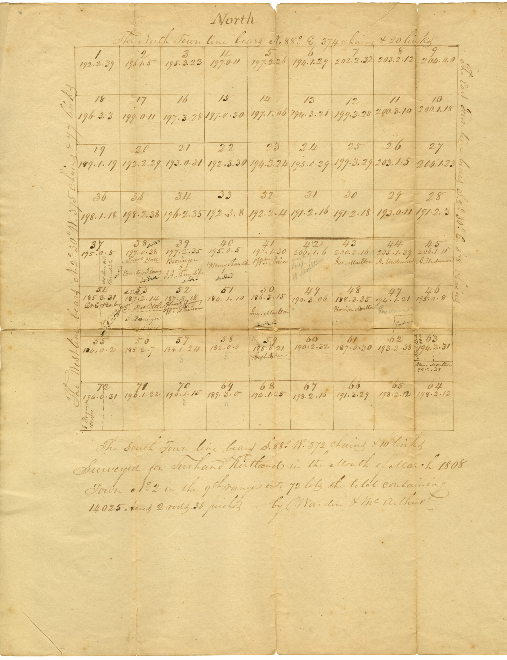
North
The North town line bears N 88o E. 374 chains + 20 links
| 1 192.2.39 | 2 196.1.5 | 3 195.3.23 | 4 197.0.11 | 5 197.2.26 | 6 194.1.29 | 7 202.2.32 | 8 203.2.12 | 9 204.0.0 |
| 18 196.3.3 | 17 199.0.11 | 16 197.3.28 | 15 197.0.30 | 14 197.1.06 | 13 194.3.21 | 12 199.3.28 | 11 200.3.10 | 10 200.1.18 |
| 19 189.1.19 | 20 192.2.29 | 21 193.0.31 | 22 192.3.30 | 23 194.3.24 | 24 195.0.29 | 25 199.3.29 | 26 203.1.15 | 27 204.1.23 |
| 36 198.1.19 | 35 198.2.38 | 34 196.2.35 | 33 192.3.8 | 32 192.2.4 | 31 191.2.4 | 30 191.2.18 | 29 193.0.11 | 28 191.2.3 |
| 37 195.0.5 100 acres sold Benedict deeded | 38 deeded 197.0.38 Jacob Hall — Erastus Flowers Deeded | 39 197.2.35 Booringer + J.A. Thorndike deeded | 40 195.0.5 Henry Thorndike deeded | 41 197.1.30 Wm. Price | 42 200.1.6 West half H. Moulton | 43 200.2.16 Increase Moulton | 44 205.1.39 A. Underwood | 45 206.1.10 A. Underwood |
| 54 185.3.31 L.+E. Barber 100 Acres Julius Blake | 53 deeded 187.2.14 G. Doolittle —- G. Boosinger | 52 187.3.18 Harris Sherman +Wm. Davison | 51 184.1.10 | 50 186.3.15 Inc[rease] Moulton deeded | 49 190.3.06 | 48 188.3.35 Harrison Moulton | 47 194.1.21 Gardner _______ Gardner | 46 195.0.8 |
| 55 184.0.2 | 56 185.2.7 | 57 186 .1.24 S | 58 182.0.0 S | 59 185.0.21 Joseph Osborn | 60 190.2.32 | 61 187.0.30 | 62 193.2.38 | 63 194.2.31 Able Burt 50 a[cres] Abner Moulton 94.2.31 |
| 72 196.0.31 S. Ferguson 100 Acres | 71 196.1.22 | 70 196.1.15 S | 69 189.3.0 S | 68 192.1.25 | 67 198.2.16 | 66 191.3.29 | 65 198.2.12 | 64 198.2.12 |
The South Town line bears S 88o W 372 chains + 10 links. Surveyed for Turhand Kirtland in the Month of March 1808. Town No 2 in the 9th range into 72 lots the total containing 14025 Acres 2 rods 35 perches by Warden + McArthur
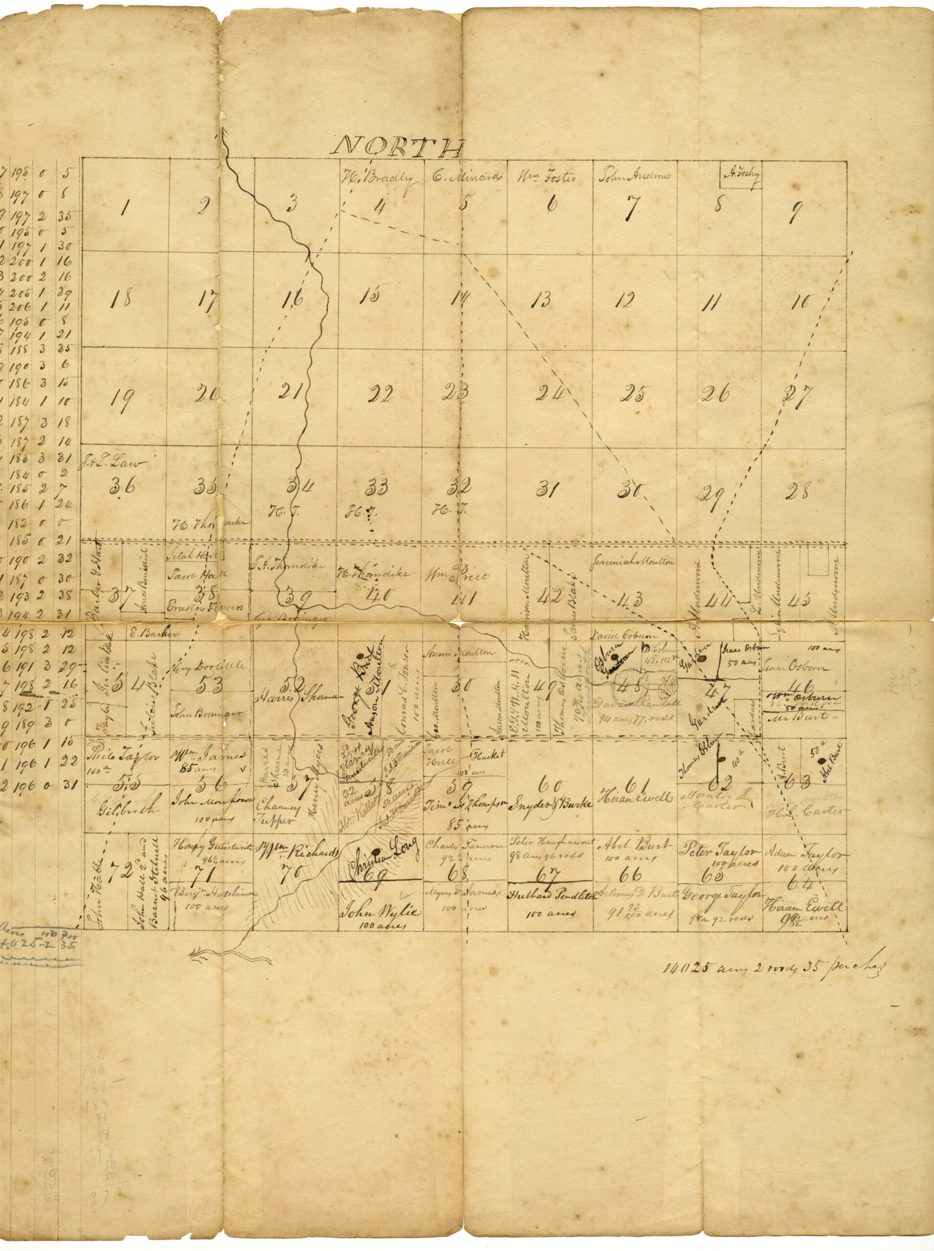
| 1 | 2 | 3 | H. Bradely 4 | C. Minard 5 | Wm. Foster 6 | John Andrews 7 | 8 | Foshy 9 |
| 18 | 17 | 16 | 15 | 14 | 13 | 12 | 11 | 10 |
| 19 | 20 | 21 | 22 | 23 | 24 | 25 | 26 | 27 |
| J. + L. Law 36 | H. Thorndike 35 | H.T. 34 | H.T. 33 | H.T. 32 | 31 | 30 | 29 | 28 |
| Barber + Hart 37 Amos Benedict E. Barker | Selah Hart Jacob Hall 38 Erastus Flowers Deeded | J.A. Thorndike 39 Geo. Booringer | H. Thorndike 40 | Wm. Price 41 | Harrison Moulton 42 James Blake | Jeremiah Moulton 43 Daniel Coburn | A. Underwood 44 | Lybia Underwood 45 A. Underwood |
| Taylor Julius Blake 54 Julius Blake | Guy Doolittle 53 John Boosinger | Harris Sherman 52 | Anson Moulton 51 Conrad C Fowser 100 acres | Anson Moulton 50 186.3.15 Geo. Moulton Anson Moulton | E.G.I.W.M.H. Moulton 49 Thomas Osbourne 90 ¾ acres | Osburn D. Coburn 43.112 48 David Randall 94 acres 77 rods | Gardner Isaac Osburn 50 acres 47 194.1.21 Gardner | 100 acres Isaac Osborn 46 Wm. Osburn 50 acres Mr. Burt |
| Philo Taylor 100 a 55 Gilbreth | Wm. James 85 acres 56 John Moulton(?) 100 acres | Harris Sherman 50 acres 57 Chauncey Tupper Henry Myers | 50 acres Henry Geistweite 50 acres Sal.(?) F. Davidson 58 32 acres Wm. Keller 50 acres Sal.(?) F. Davidson | Jacob Hull Hackett 100 acres 59 185.0.21 Tim Thompson 85 acres | 60 Snyder Burke | 61 Hiram Ewell | Thomas Osburn 40 a 62 Horatio S. Carter | A. Burt Able Burt 50 a Abner Moulton H.L. Carter |
| John Hall 72 John Hall 2d and Barnet Stilwell 96 acres | Henry Geistweite 96 ¼ acres 71 Benj. Hutchinson | Wm. Richards 70 | Christian Long 69 John Wylie 100 acres | Charles Fanorman(?) 92 ¼ acres 68 Myers & James 100 acres | Peter Haughawout 98 acres 96 rods 67 Hubbard Pendleton 100 acres | Abel Burt 100 acres 66 Artemis D. Burt 91 93/100 acres | Peter Taylor 100 acres 65 George Taylor 98a 92 rods | Adam Taylor 100 acres 64 Hiram Ewell 98 ½ acres |