Connecticut
In order to better understand this archival collection, it is important to provide a historical narrative that is not always told. The primary source documents date from 1796 into the 1830s. However, there are long Indigenous histories throughout North America that have existed around 12,000 years before British colonization and American expansion. Here is a list of Native American tribes in the Native Northeast, what is now Connecticut, at the turn of the sixteenth century:
Nipmucs, Sequin (“River Indians”): Podunk, Poquonook, Quinnipiac, and Tunxis; Matabesec (Wappinger Confederacy) Western region of Connecticut and Eastern New York: Pootatuck, Weewaug, and Unocwa; Mohegans, Pequot, and many other Native groups that rooted sovereignty and communities in proximity to rivers, lakes, and forests. Major rivers in CT that were utilized for fishing and other agricultural uses were the Quinnetukut, an Algonquin word, and the Nipmuc word, kwinitekw, which means “beside the long, tidal river,” now the Connecticut River. Other important rivers include the Thames, the Housatonic River, the Niantic River, and the Farmington River.
Before the policing of national and state borders in the United States, land territories were more fluid but with an understanding of generational and ancestral ties to specific regions. Once British and Dutch settlers and their companies started to create colonies in Connecticut in the 1630s, Indigenous groups in the Northeast experienced enslavement, disease, colonial violence, and land dispossession for centuries to come. This Western Reserve collection can show how certain correspondence of land distribution have erased and left out the narrative of Indigenous land dispossession. This page acts as Indigenous historical context to these archives and shows how these places were not free open land for the taking.
Pertaining to the geographical locations that are relevant for this collection, the first colonial settlement in Hartford was 1636. Violence and war between Europeans and Native groups resulted in the English colonizers to expand their control of the region. This set the environment for the Colony of Connecticut to be able to receive rights to land in the Western Reserve. The three largest Native groups in the Hartford region are the Podunks, Sicaog, and Poquonook tribes. The Colony of Connecticut stole their lands in order to gain control and power over the rivers, forests, and people.
Brimfield, MA
The collection also includes Brimfield, Massachusetts which is close to the current state border between southern Massachusetts and Northeast Connecticut. Brimfield holds a long Indigenous history as a village called Asquoash, a fortified stronghold in this area and an important stopping point on several trails used and run by the Nipmucs. Europeans from Springfield, MA set off towards present day Brimfield to find new suitable land for a new plantation and later named the land and topography Brimfield Valley, Tower Hill, and the Quabaug River. This region is surrounded by hills and a small mountain range, Steerage Rock Mountain. The Chicopee River is westward and this region was occupied by the Agawam and Nipmuc peoples before colonization.
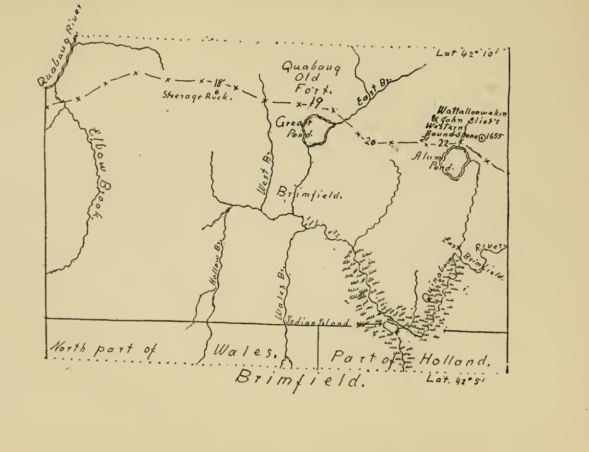
A map of Brimfield, MA circa 1655 (Badger Chase, 65).
An interactive map from Native Land Digital that shows the first inhabitants Indigenous groups and territories before and during the establishment of Connecticut and its’ borders.
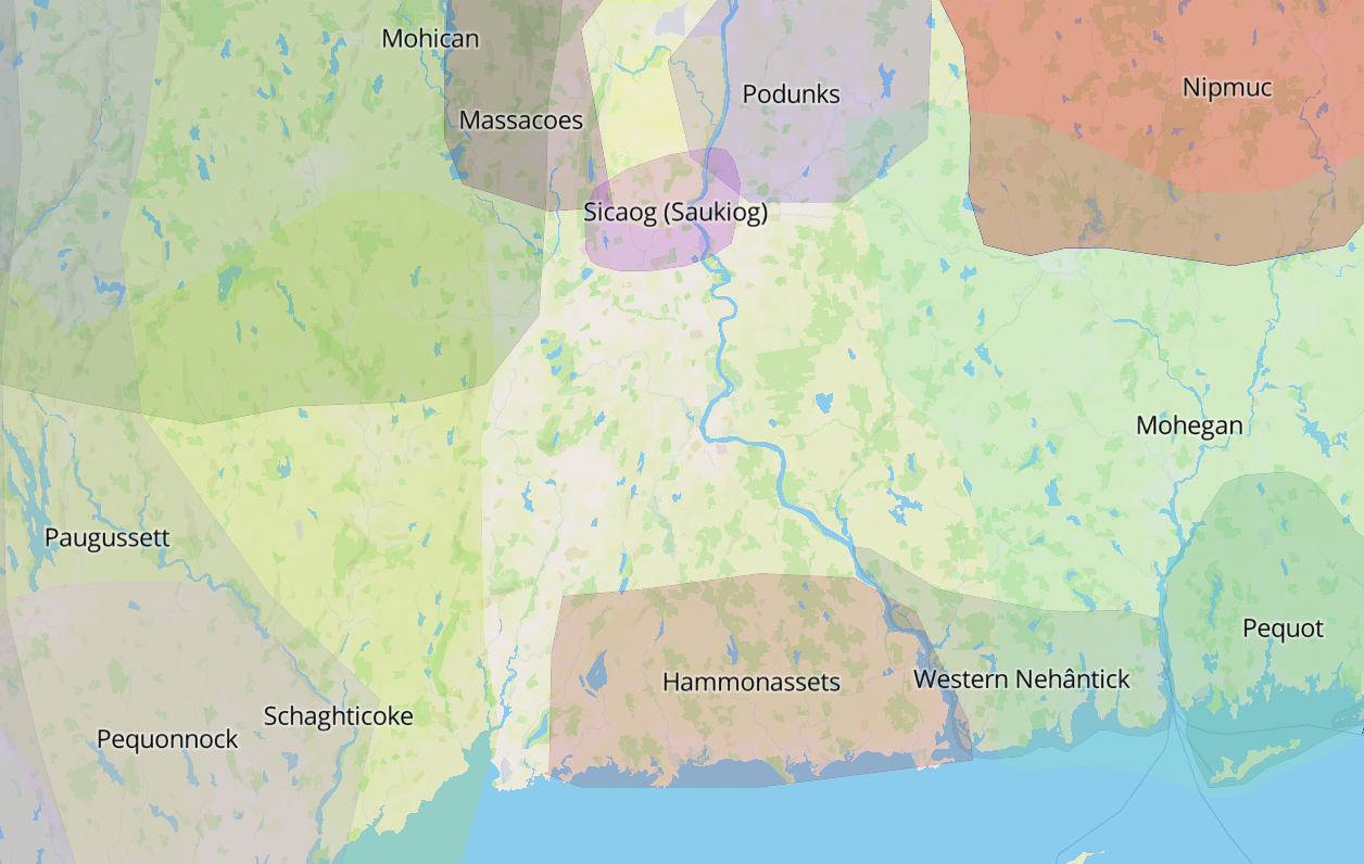
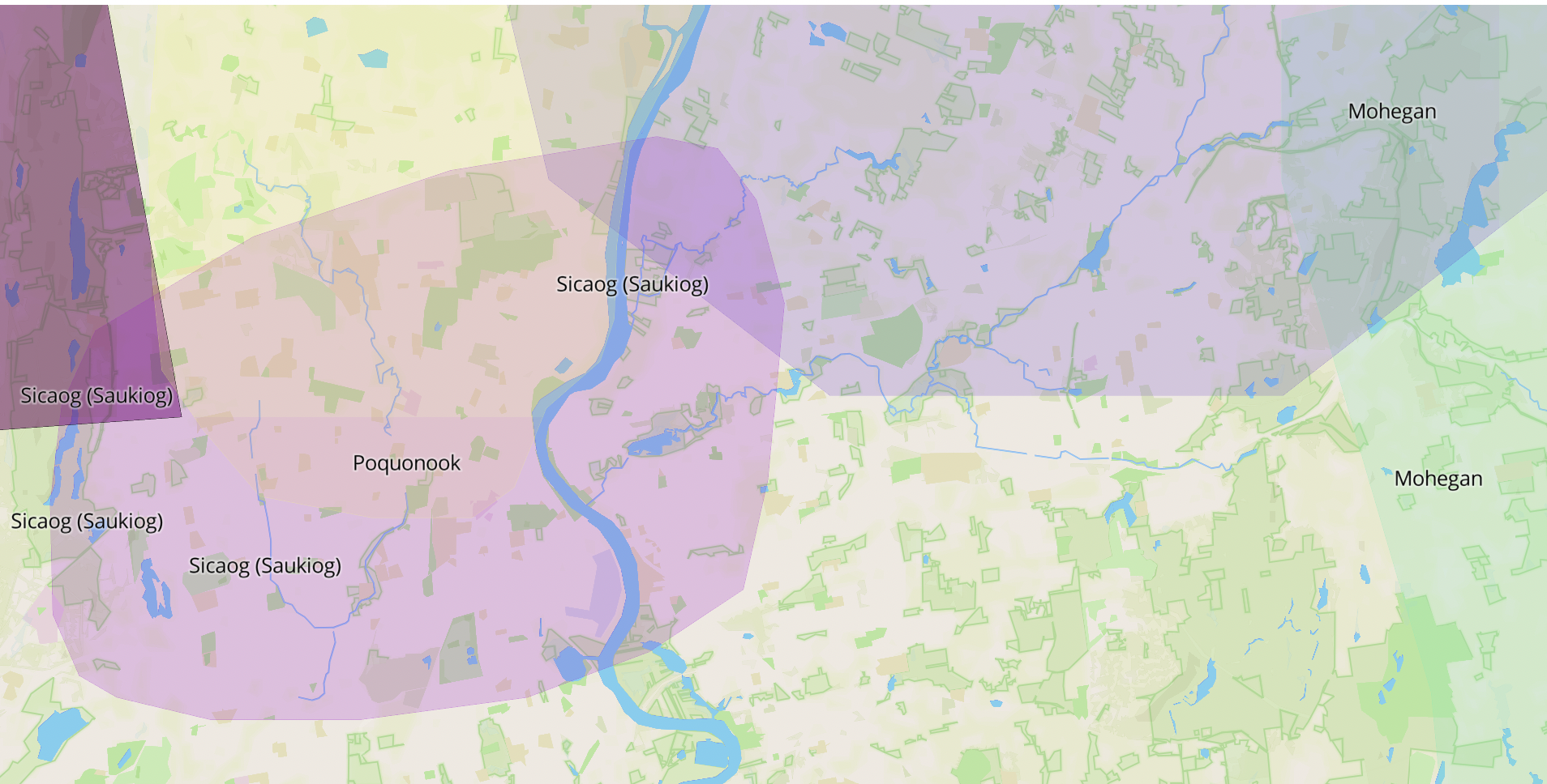
The purple circle on the map shows Indigenous groups in the Hartford, CT area, Sicaog, Poquonook, and Podunks – the collection holds many letters written in Hartford and East Hartford in the late 1700s and early 1800s.
Sources
- Badger Chase, Levi. 1919. “The Bay Path and along the Way.” https://ia601305.us.archive.org/22/items/baypathalongway00chas/baypathalongway00chas.pdf.
- Baker & Tilden Case, Kellogg & Bulkeley, and Lockwood & Brainard Co. 1869.
- “Map of Connecticut.” Library of Congress, Washington, D.C. 20540 USA. 1869. https://www.loc.gov/resource/g3783hm.gla00222/?sp=4&r=-0.157.
- “CT Early History.” n.d. CT.gov – Connecticut’s Official State Website. https://portal.ct.gov/About/Early-History.
- DeLucia, Christine M. “Algonquian Diasporas: Indigenous Bondages, Fugitive Geographies, and the Edges of Atlantic Memories.” In Memory Lands: King Philip’s War and the Place of Violence in the Northeast, 289–324. Yale University Press, 2018. https://doi.org/10.2307/j.ctt1z27j8q.12.
- “LibGuides Home: Native American Research: List of Historical Connecticut Tribes.” 2024. Libguides.ctstatelibrary.org. 2024. https://libguides.ctstatelibrary.org/hg/nativeamericans/cttribes.
- Native Land Digital. 2024. “NativeLand.ca.” Native Land Digital. 2024. https://native-land.ca/.
- “The History of Early Hartford, CT | Founders of Hartford.” 2020. Foundersofhartford.org. 2020. https://www.foundersofhartford.org/historic-hartford/history-of-early-hartford/.
- W. Parker, Lester. 1964. “Treasures from the Sherman Room the Story of Tower Hill.” http://brimfieldpubliclibrary.com/wp-content/uploads/2020/08/TowerHillPamphlet.pdf.
Pennsylvania
In telling Indigenous histories, it is important to avoid declension narratives that only reference Indigenous people in the past tense or in a way that implies a decline in Native culture and presence. Instead writing about Native peoples survival and resistance against settler colonial forces – survivance, helps to recenter American history around Indigenous experiences.
The largest Native groups in what is now Pennsylvania included the Iroquois, Munsee Delaware, Erie, Shawnee, and Susquehannock. Erie, Iroquois, and Susquehannock speak dialects of the Iroquoian language. The Shawnee, Munsee, and Lenape Delaware are in the Algonquian language family. The Native people in this region at the time were seasonally and traditionally nomadic. These lands have a variety of mountains, hills, and river valleys such as the Appalachian Mountains and the Allegheny Mountains in the West. Major bodies of water that communities relied on were Lake Erie, the Delaware River, the Susquehanna and Ohio rivers.
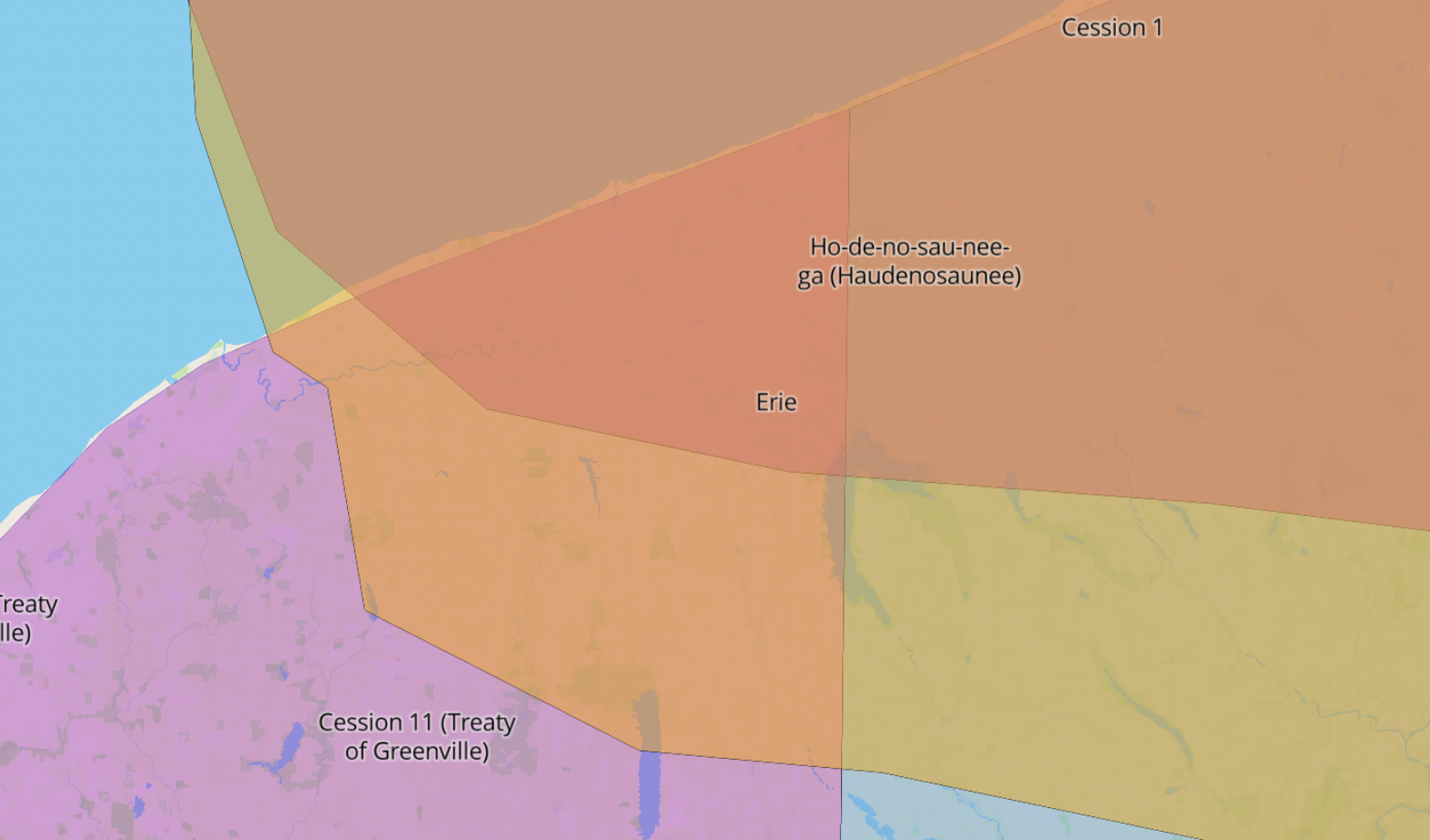
This Western Reserve collection contains many letters surrounding business and events from Presque Isle which is now in Erie, PA that was once a French fort, a British fort, and then reclaimed by a coalition consisting of the Ottawas, Ojibwas, Wyandots, and Seneca in 1763. Presque Isle was originally Erie territory and occasionally under Iroquois control before colonization and military expansion. A portion of Iroquois and Haudenosaunee lived in present day Northwestern PA, the Southern shore of Lake Erie. Presque Isle is a complex example of what borderlands look like and the crossing of boundaries, control, and power. Presque Isle also demonstrates the resiliency of Native peoples in this region throughout experiencing settler colonialisms. There were many different Indigenous peoples in this region and it adds a nuanced history to the documents in this archive.
This map illustrates Haudenosaunee and Erie territory in present Northwestern PA where Presque Isle is located and also demonstrates different types of borderlands between territories.
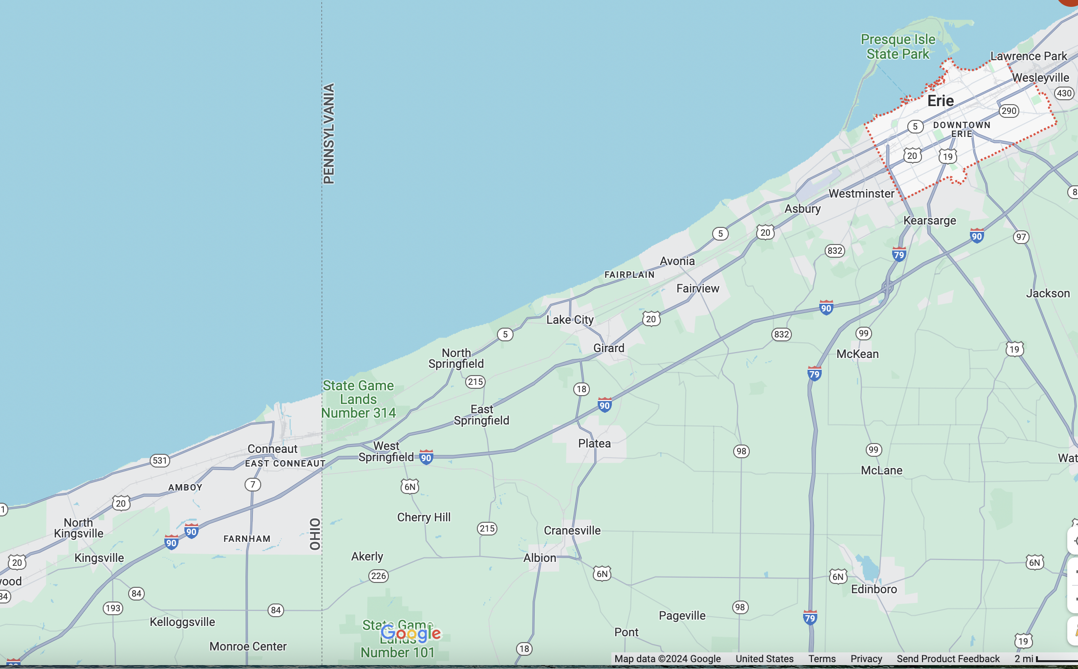
Current day map of Erie, PA and Presque Isle. State and town borders between Ohio and PA – an image to compare pre and post-colonial land divisions and as a result of imperial expansion, more dispossessed Indigenous lands.
Sources
- Forbes, Tench. 1753. “A Brief History of Fort Presque Isle: May, 1753.” SCWPA. May 1, 1753. https://colonialwarspa.org/brief-history-fort-presque-isle-may-1753/.
- Geiger. 2023. “Native Americans in Pennsylvania from Pre-Colonial Areas to Post-Independence Movements.” Mapmaker.millersville.edu. 2023. https://mapmaker.millersville.edu/pamaps/NativeAmericans/.
- Myers, Sarah. 2024. “Research Guides: History: Indigenous History of Pennsylvania.” Libguides.messiah.edu. January 31, 2024. https://libguides.messiah.edu/history/indigenous.
- “Pennsylvania Topo Map – Topographical Map.” n.d. Www.pennsylvania-Map.org. https://www.pennsylvania-map.org/topo-map.htm#:~:text=Most%20of%20Pennsylvania%20is%20covered.
- White, Richard. 1991. The Middle Ground : Indians, Empires, and Republics in the Great Lakes Region, 1650-1815. Cambridge ; New York: Cambridge University Press.
Ohio
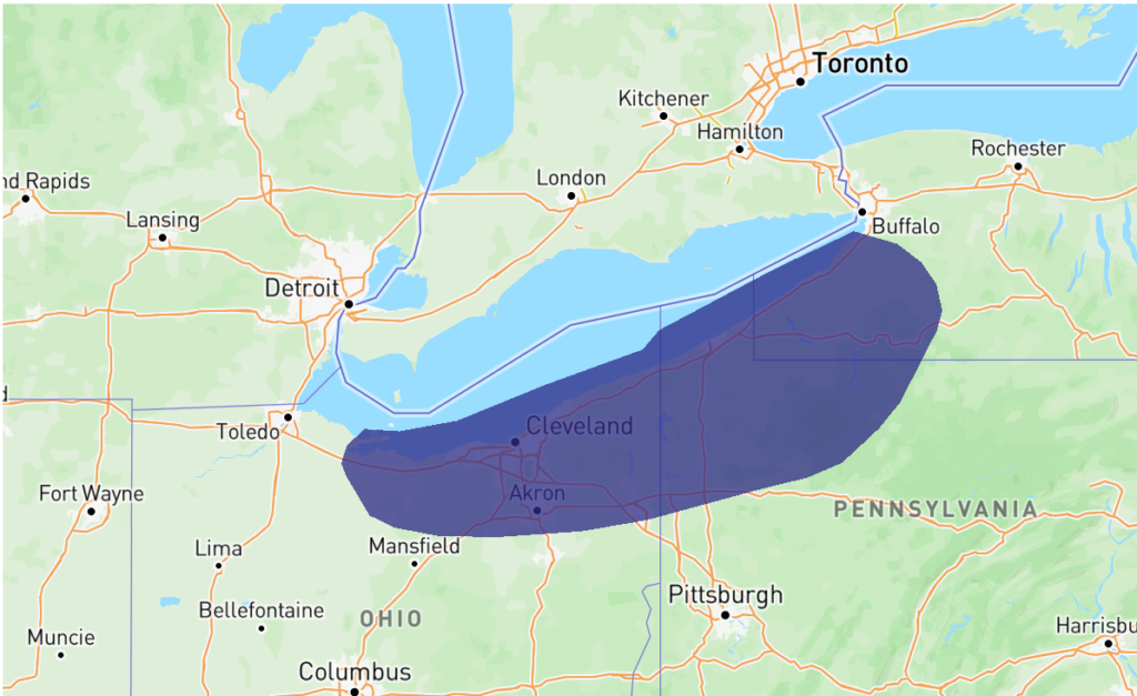
Map from Native Land Digital of the territory of the Erie on a modern map. One of many Indigenous nations in what is now Ohio. The Erie’s territory included the land that is now Cleveland and Ravenna in Ohio and Presque Isle in Pennsylvania, locations referenced in the letters. The Erie lost their lands and their survivors were scattered by 1655 by conflict with the Haudenosaunee, conflict somewhat triggered by European pressures. Five years later the Western Reserve was established.
Indigenous nations within what is now Ohio include: Shawnee, Iroquois, Wyandots, Miamis, Delawares, and Chickasaw
The Erie
The story of the Erie is an example of the far-reaching consequences of colonialism. Unlike the Haudenosaunee(Iroquois Confederacy), the Erie had very little direct contact with Europeans. The first European record of the Erie comes from Father Gabriel Sagard in 1624 when he was working with the Wendat (Huron) making a dictionary; he translated Erie’s name as ‘Cat Nation’ or ‘Cat People.’ Jesuit Missionaries recorded their presence in 1635 but had very little or possibly no direct contact with them. The Erie were an Iroquois people, but they did not join the Haudenosaunee, an alliance of five Iroquois tribes. In the Iroquois political and social structure, women had very active roles. Clans were matrilineal, so inheritance was through mothers, and families were led by a matron. Erie women also had significantly better marriage rights compared to European women at the time; husbands would join the wife’s family, and divorce was available. This does not mean that the Erie were matriarchal as the whole tribe would typically be led by a council of eight male chiefs, but women held considerable and in-theory equal power. David Cusick, a Tuscarora writer, wrote “Sketches of ancient history of the Six Nations” in approximately 1840. This book is a mix of history and myth around the founding of the Haudenosaunee and other Iroquois stories. In this text, he tells the story of Queen Yagowanea, a leader of the Erie, who was known for her policy of neutrality with the Wendat and the Haudenosaunee, neutrality often maintained through scarring off enemies. This policy of neutrality led to the Erie housing Wendat refugees after their conflict with the Haudenosaunee. When they refused to give up the refugees, they were nearly wiped out in the following conflict, and they lost their lands and any survivors scattered. The Haudenosaunee’s conflict with the Wendat and then the Erie was largely driven by European pressures. The Erie had very little to no direct contact with Europeans, but the Haudenosaunee traded extensively with Europeans. As European incursion into North America increased, the Haudenosaunee were driven to expand their territory to make up for lost land, resources, and deaths. That expansion of their territory drove them into increasing conflict with their neighbors, among them the Wendat and then the Erie. The Erie, despite possibly never coming into direct contact with Europeans, were still entirely dispossessed by the effects of colonization by 1655, five years before Connecticut’s Western Reserve was even established
Sources
Cusick, David, -Approximately 1840. David Cusick’s Sketches of ancient history of the Six Nations: comprising, first, a tale of the foundation of the great island now North America, the two infants born, and the creation of the universe. Second, a real account of the early settlers of North America, and their dissentions. Third, origin of the kingdom of the Five Nations, which was called a long house: the wars, fierce animals, &c. [Tuscarora Village, Lewiston, Niagra Co., Lockport. N.Y.: Cooley & Lothrop, printers, 1828] Pdf. https://www.loc.gov/item/06003795/.
Charles River Editors, March 2nd 2021. The Erie: The History and Legacy of the Native American Group
There were many other indigenous nations in what is now Ohio at this time and after each with their own histories, the Erie are just one example.
For information on Treaty of Greenfield.
Illinois
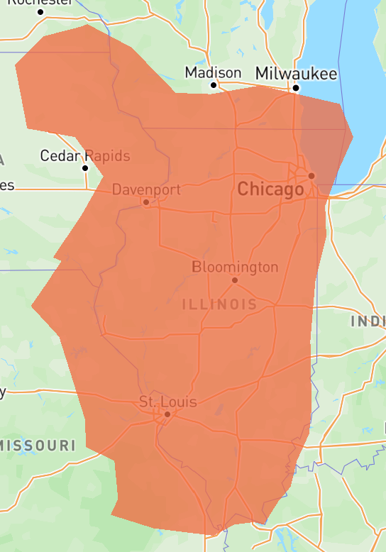
Map from Native Land Digital showing the general spread of the Illinois language. This Indigenous Empire included the city of Cahokia, modern St. Louis, and was an alliance of roughly eleven Algonquin tribes.
“Although dispersed from what is now Iowa to present-day Arkansas, the eleven divisions of the Illinois composed a single nation, united by kinship, language, ceremony, and commerce. The same was true for Osages, Miamis, and other nations that maintained distinct villages separated by many miles”
Jacob F. Lee, Masters of the Middle Waters: Indian Nations and Colonial Ambitions along the Mississippi (Cambridge: Harvard University Press, 2019), 4-5.
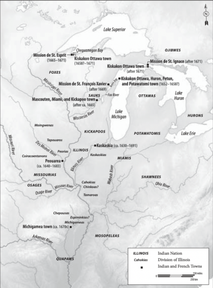
Map of Illinois territory circa 1673 (Lee, 14)
Indigenous nations within what is now Illinois include: Illinois, Kaskaskia, Kickapoo, Osages, Miamis, and Dakhota
There are debates over definitions of Empire and how they apply to Indigenous nations but the Illinois certainly showed Imperialist behaviors.
“During the seventeenth century, Illinois Indians took control of the central Mississippi River valley by seizing important crossings and confluences. In command of choke points, Illinois built commercial and political alliances with neighboring nations. Soon, they controlled the trade in slaves, furs, and European goods between the western Great Lakes, eastern Great Plains, and lower Mississippi valley. Illinois power stemmed from their ability to travel unhindered from Lake Superior to present-day Arkansas and from Lake Michigan west onto the Plains.”
Jacob F. Lee, Masters of the Middle Waters: Indian Nations and Colonial Ambitions along the Mississippi (Cambridge: Harvard University Press, 2019), 9.
The Illinois had a lot of power and controlled much of the Mississippi river and its tributaries and European forces, mostly the French and Spanish, needed allies to continue imperialist efforts in the region. They found those allies among the Illinois, at least for a while. The French and Spanish got their rights to use of rivers and waterways from the Illinois but during westward expansion the US got the rights from European powers in the region .
By the time the US arrived in middle America the region had already been irreversibly affected and devastated, adding to the myth that North America was ‘empty’, ‘virgin’ land ready for settlement.
For information on myth of ‘virgin’ land.